
Another weekend, another 14er! We were able to leave
early-ish, and got on the trail by 8am on June 21st. The weather was
looking perfect, once again, and the three of us were in great spirits. Rather
than make the trek easy, we started at one of the furthest trailheads, at Echo
lake, knowing the route would be about 16 miles. We also didn’t learn our
lesson from the last hike, and didn’t bring any trail guides with us in case we
lost our route. Such Newbies!
 |
| Echo Lake |
Ryan, Jon,
Cody and I did some run-hiking for the first 5 miles. Anytime we start above
10,000 feet, I’m happy to maintain a 10-11 min mile, since I still hadn’t
adapted to altitude. The trail was gorgeous, taking us through some pine
forests, and meadows with stunning lakes.


At around
the 5 mile point, we began the really big ascents. We followed the trail that
switch-backed up the side of the mountain. As we stopped to catch our breath,
we realized that a herd of big horn sheep were hanging out on the hillside,
watching the silly humans try to ‘run’ up a mountain. Cody was amazing- she
didn’t show any interest in the sheep (she must not have seen them!).
 |
| There really are sheep in this picture- they just blend in so well! |
 |
| This is the trail. It was steep. Cody didn't even notice. |
 |
| Chicago Lake |
 |
| Looking down on Chicago lake from above |
We took a
food break at the Summit Lake parking lot. We hadn’t seen a single other hiker
from Echo lake to Summit lake, so it was interesting to pop out of the trail,
into a parking lot filled with people and cars!
 |
| Summit Lake |
 |
| Looking down on Summit Lake |
Finding the
next part of the route was a little tricky, and we spent the rest of our time
navigating over lots of rocks, trying to find the route. Here’s where having a
route description or guide would’ve been helpful, because we started to summit
something that was not Mount Evans. We finally got used to looking for cairns,
and managed to keep making progress on the correct trail. Cody was a champ at
the rocks- this time, we really had to climb up, and in a few spots, she needed
a boost.
 |
| Cody- part dog, part mountain goat |
 |
| Route finding |
After what
seemed like hours, we eventually made it to the actual summit. Again, after
seeing only a few other hikers for the last hour, we emerged at 14,000 feet
into a huge parking lot, with REAL bathrooms, cars and motorcycles. The final
300 foot climb to the summit was like a Disneyland route, but I was happy it
exists, because it allows people who aren’t as able-bodied to see the
incredible summit of a 14,000 foot peak.
 |
| View from the top |
 |
| Summit Dog! |

 |
| The saddle trail over to Mt. Bierstadt |
After enjoying
the views and the steady wind on the summit, we went over to see why everyone
was hanging around this older building. Turns out, mountain goats live
there! There were some baby twin mountain goats and their parents hanging out,
posing for pictures. We went to check them out, and Cody was amazing again-
completely ignoring the wildlife. The little baby mountain goat got a whiff of
Cody, and got nervous, scrambling up the rocks and away, until his Mom let him
know it was OK.

Crying for his mom!
The
scramble down the summit was a lot harder than our previous descents. We didn’t
have any snow to slide down, and the rocks were slippery. We also had been up
past 14,000 feet for almost 2 hours at this point, and all 3 of us humans were
starting to feel loopy and uncoordinated. Ryan and Jon had run out of water, so we had to stop at a mountain stream for them to fill up.

 |
| Running down from the summit |
 |
| Mr. Mountain Goat, posing on a rock |
By the time we got to an area that was more runnable, my legs were exhausted and I was low on fuel, so we couldn’t quite run back as hard as we would’ve liked to. Finally, we made it back to the car, after a vicious 300 foot final ascent. This was the first hike that tested our limits a bit- from the difficult route finding, to the additional time spent at higher altitude, we were pretty happy to be done. Our expectations were that this was supposed to be ‘easy’, but maybe now we’ll finally learn that there is NO easy 14er!!!

Overview:
If you start at Echo Lake, you can get a lot of good trail
running in for the first 5-6 miles. If you’re a beast (like Ryan and Jon), you
may even be able to run up to 7 miles- but it’s really steep. The remaining
climb gets a bit technical, and requires more scrambling. I'd suggest wearing cheap gloves that you don't mind running, to help protect your hands when scrambling over rocks.
Details
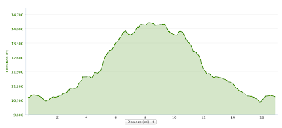
Total time: 7:09
Moving time: 5:09 (18:19 min/mile). Again- a TON of time
taking pictures!!
Starting elevation: 10,409 feet
Max elevation: 14,304 feet
Total ascent: 5,571 feet
Elevation Profile:
Cody wore her UltraPaws boots to protect her feet on the hike, and rocked her Julius K9 harness.

Gear
My essential Brooks LSD lightweight running jacket, Salomon Speedcross and my Nathan hydration vest. Ryan wore his Ultimate Direction Wasp vest and his Salomon sense Ultras.Cody wore her UltraPaws boots to protect her feet on the hike, and rocked her Julius K9 harness.
This adventure looks really tiring and fun. I recommend to use paw protection, such as Walkee Paws leggings, this can help keep your dog's paws safe from hidden dangers.
ReplyDeleteLearn more: https://walkeepaws.com/