Monday, August 4, 2014

Trip Report: Uncompahgre


Our trip up to Uncompaghre was broken into 2 days:

After successfully running Sunshine/Redcloud, we headed to Lake City for some lunch/dinner, then headed out on another dirt road crowded with ATVs and Jeeps and tried to go up the 4WD one lane road to the Uncompaghre trailhead. No way were we making it up this rutted out, boulder strewn road. We didn't even make it 10 feet, so we parked at a dispersed campsite, packed up our backpacking gear and headed up the road...into a rain storm. No problem, it's only a 2 mile hike up to the trailhead, right?! Nope, turned out to be 4.5 miles and all uphill for 2,000 feet of vertical gain (reading comprehension skills, Alaina?!). 

Ryan got a little grumpy. And by grumpy, he complained with every step of the 2,500 feet of gain ;) It was a long walk with a pack that might have been only 15lbs but felt like 100lbs. We made it in the light and set up our camp in the woods and tried to start a fire. Little too soggy for that. Oh well, we saw an incredible sunset over the mountains and cashed out early.


Next morning up with the sun and onto the trail up Uncompahgre Peak for our 4th 14er of the weekend. All 3 of us were tired, but at least Cody's boots allowed her to complete the hike.


Our hike started at 11,500 feet, just past the trailhead. The first half of the hike was a lot more runnable than the other 14ers we had done over the weekend, but we were too tired to try.


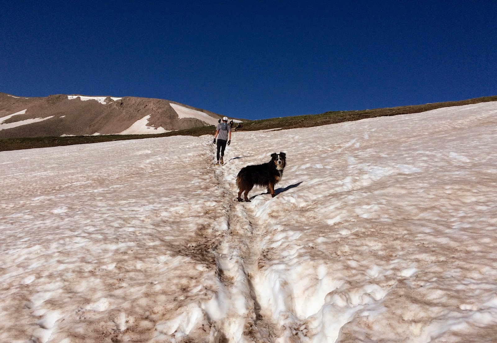
The non-runnable part was a scramble up a scree field just at the top of mountain. Cody was a little billy goat, running up with no fear, while her parents cautiously picked their way through the rocks.


The landscape on this trail was very different than Handies- not quite as inspiring, but unique in it's own right, especially because the funny looking Uncompahgre Mountain was always just up ahead.


The top had incredible views, as always. This trail is more out of the way than most so it was nice to be on top with only a few other hikers (compared to the party atop Redcloud/Sunshine). While we were rejuvantating at 14,000 feet, a plane flew by. We were so high up that the plane was at eye level. Now that was cool!


Running back down was great fun, glissading down some snow fields and taking pics and videos. We'd finally woken up by then.

And back at camp, we packed up our site then met up with a couple at the trailhead who had driven their truck up, so Alaina and Cody took a ride with them back down while Ryan ran down super fast, beating the car travelers by 15 minutes!

Overall this was a very fun hike. If you start at the bottom of the 4WD road it would be an 11.87 mile run 5,760 feet of total climbing, most of which is runnable. The trail is also mostly dirt pack, with some rockier sections. The only time sticky/sturdy shoes are needed is for the last scramble.


Thursday, July 10, 2014

Trip Report: Redcloud and Sunshine


Day 2 (July 5th, 2014)
After a wonderful night's sleep in the Element Camper, we were up early (for us) to climb Redcloud and Sunshine. This trail turned out to be more gradual than Handies. After a short but steep hike through the forest, we quickly hit tree line that opened up into a gorgeous valley.


The trail was busy but everyone we passed was very accommodating and made room on the trail. Sometimes it's like a race out there, we get so many people who encourage us along the way- some exclaiming "Y'all are awesome!".


When we reached the top, the red rock on the summit was amazing -- sometimes it looked like we were crossing the moon or mars!


This is an interesting out-n-back route where you go over Redcloud, down the 500' saddle then up to Sunshine, but you need to backtrack and go up and over Redcloud to get back to the trailhead. I love the view of the peaks up the basin. You can see the ant people on the route the whole way up.
Look- a flat section at 14,000 feet!

Crossing the saddle between Redcloud and Sunshine

Most of the trail wasn't too scary- except for the few spots like this!

Ryan runs up the saddle (for about 20 seconds....)
The summit of Sunshine was even more crowded. It seemed like everyone from tent city at Grizzly Gulch was up on the summit. Sometimes it's fun to be in the middle of nowhere, and be mostly alone all day, but still find those other groups that enjoy the mountains as much as you do.


We ran hard downhill as the dark clouds approached and warned a few folks about the changing skies. I think some people behind us got quite wet as we were pelted with hail just as we reached tree cover. Phew! Another close call.


Safely we made it back to the car, but Cody's poor paws were hurting and she was lagging behind. Tomorrow we'd give the booties a try. We packed up our mini-camp and drove behind a line of cars back down the one lane dirt road, just squeezing by a few Jeeps. 

When we made it back to Lake City for some hot food at Country Vittles restaurant, we discovered that Lake City is essentially little Texas. Boots and cowboy hats and Texas stuff on the walls. Many Texas accents in that joint. Very odd little town- but cute and welcoming!

After we finished a yummy lunch, we headed up to our next trailhead to tackle Uncompahgre!

Summary:

Distance: 12.47 miles
Total Time: 4:29:41
Moving Time: 3:58:30 (19:08 min/mile)
Starting Elevation: 10,415 feet
Max Elevation: 14,030 feet
Total Climb: 4,783 feet


Wednesday, July 9, 2014

Trip Report: Handies Peak


Three day weekend! To celebrate our country, we decided to climb some of it's highest peaks! The southern San Juan's are just a little too far for our typical weekend adventure, so we took advantage of the July 4th holiday weekend to drive the 5.5 hours to climb some mountains.

Thinking that 8:30pm on a Thursday would get us clear of traffic, we were disheartened to be stopped in a gridlock 20 minutes into the drive. We made it just past Gunnison by 1:30 am to a lake with no restrictions on overnight parking. We camped in the Element with a very content Cody pup and awoke to the sun over the mountains above us and a gorgeous, placid lake below us.


Lake City was only an hour away, so we had a short-ish, but very beautiful drive up a canyon to our trailhead campsite for the next night. We did have to drive on a 3mi stretch of one lane (barely) 2WD road, along a huge cliff with deadly dropoffs! Adventure indeed. But the Grizzly Gulch TH where were were setting up basecamp leads to three different 14ers, so it was totally worth it. Despite being in the middle of nowhere, the trailhead was packed- and it was tent city. Tons of trailhead camping here.
View on the drive in (through the windshield)

Around 10am we packed up our ultralight running vests and Justin Case storm gear and blistered our way to the top of Handies Peak at 14,058', which is also the highest point on the Hardrock 100 course. I can't believe how hard that race course is! The views as we ran up the valley were simply incredible. Handies in front of us and Sunshine/Redcloud behind.

Gorgeous trail to Handies
Wildflowers on the way up to Handies

Redcloud and Sunshine behind us


The hike up from Grizzly Gulch was a bit steeper than we had expected, but the trail itself isn't too technical.

Creek Crossing!

As we get to the ridge line, here are some of the views:


The final approach to the top was a little tricky, but that was mostly because we lost the trail in the snow. Once on the summit, the views were some of the best we've seen. There is literally no sign of civilization for 360 degrees.


This is the Hardrock course- runners summit Handies from this trail
I am climbing up the first part of the descent on the Hardrock course
We met a couple guys at the top who had either done Hardrock or were doing it next weekend- Ryan was super jealous, obviously, while Alaina told them they were all nuts ;)

Cody had a blast the entire time. She just loves climbing these 14ers!
17th Fourteener for Cody the AdventureDog!


Running down from the peak was tons of fun, stopping only to take some vanity shots and video because that's how we roll.


Those clouds just kept getting darker and more foreboding as our day continued

Just as we got back to the car a storm came in so we sat in the car and had some beverages and read our books and listened to music while the little bear slept. When she woke up it was time for another hike, so we recce'd tomorrow's route and threw some sticks. Everyone crashed out before sunset in the back of the Element for a long night's sleep.


Sleeping Bear

Re-energized Bear!


Ryan approves of this view!


Summary:

Distance: 8.18 miles
Total Time: 3:13:49
Moving Time: 2:43:15 (20:09 min/mile)
Starting Elevation: 10,407 feet
Max Elevation: 14,027 feet
Total Climb: 3,619 feet